Land and Property of Andrew Brosnahan/Brosnaham, Catskill, New York

Sanborn Map of Catskill, June 1889

Brosnaham Street begins where Main Street & Water Street come together, just after Main Street curves down toward Catskill Creek.


Andrew was an innkeeper licensed to sell "spirituous liquors." None of the documents noted where “Brosnaham’s” was located except that it was at the upper end of town, meaning the north end. The Sanborn Map of Catskill, June 1889, showed a short stretch of road called Brosnaham Street which ran from the end of Main Street, where it curves to meet Water Street - the closest street to Catskill Creek. It continued over the Hans Vosen Kill, or Creek - Vosenkill - and ended at the Susquehanna Turnpike. The turnpike actually began at Main Street near the Hudson River and the turnpike was the same as Main Street, but on maps, the turnpike was shown as starting at the far end of town. On current maps, Brosnaham Street is called Main Street, but for awhile this section of the road was known as Brosnham Street and it seemed likely that Andrew’s hotel was located along this stretch of road.

Sanborn Map of Catskill, June 1889

Brosnaham Street crosses the Vossenkill (which enters Catskill Creek by the large number 2 on the map) and ends where the Susquehanna Turnpike begins on this map. Catskill Creek is on the right.


Andrew began buying property shortly after arriving in Catskill. He bought his first piece in the spring of 1790 from Thomas Thompson, and his wife, Sarah, of Catskill. He paid £100 for “Lot #4 in the subdivision of Lot #66 in the County of Albany on the west side of the Catskill or Blew Mountains, part of a tract of 14,969 acres of land granted on the 11 July 1767 to Martin G. Van Bergen and others known by the 3d Tract in said Patent.” This parcel began “at a hemlock tree marked on the west side with the letters TT standing on the North bank of a brook called and known by the name of the west branch of Hunts Brook.” He next acquired Lots #3, 4, & 6 in the Town of Catskill, in a subdivision of Lot #9 in the first division of the patent of Femmen Hook” from Martin G. Schuneman and his wife Catherine, of Catskill, and Wilhalmas Schuneman and his wife Catherine in 1794. His third purchase, in 1794, was “near Catskill Landing, part of a lot of land known as Lot #4, 23 acres, 2 roods, and 32 perches; this westernmost part of said Lot #4 contains five acres, 2 roods and 32 perches.” The grantor was Elnathan Fitch of Catskill.

Andrew continued buying parcels of land – fourteen more, the last in 1832, the year before he died. It appears that most of the parcels were along the Catskill Creek, by the turnpike and by the Vossenkill, and that some were adjacent to each other. Several mention Catskill Landing and two mention Jefferson. Others that Andrew purchased land from over the years included Henry Oothoudt, John and Elizabeth Pruden, Samuel and Mary Chichester, John and Sally Bogardus, William and Sarah Robb, William and Sally Robb, William and Hannah Nelson Jr., John and Salley Bogardus, Angelica Overbagh, Jacob and Harriet Van Orden, Samuel Van Orden, James and Nancy Powers, Gertrude Van Orden, Charles Lagarenne of France, Henry and Sarah Demarest, Joseph and Mary Allen, John Van Vechten, Abraham A. Salisbury and William Schuneman Jr., executor of the last will and testament of Martin G. Schuneman.1

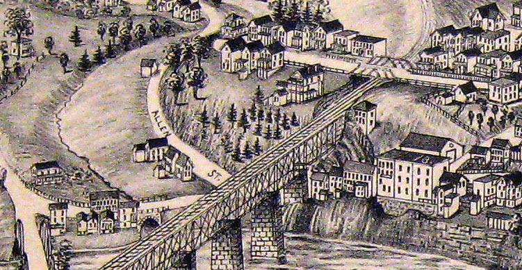
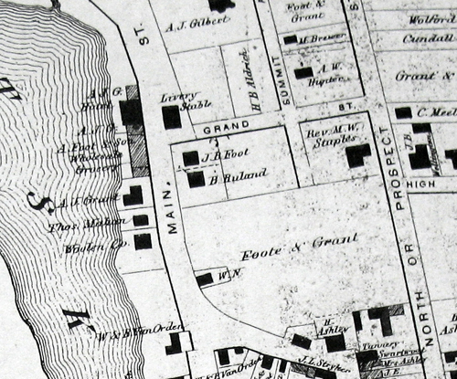
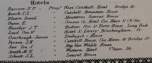
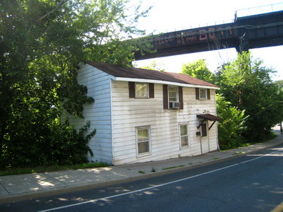
In “Dear Old Greene County” the author, F.A. Gallt, notes, “In the early 30’s there was the Brossenham hotel near the West Shore Bridge on Upper Main street, conducted by Foote and Grant, two conspicuous men of their day. This was a drover’s hotel. The building is still standing. Just beyond this [the Brossenham hotel] was the Bull’s Head, kept by Wm. Salisbury.”2 The hotel kept by Mr. Salisbury was up the road from the Brosnaham hotel, on the Northeast side of the Vossenkill near the old Allen house and shown on a map hand drawn by a Mr. F. Salisbury and entitled “The Allen House in 1848.”3
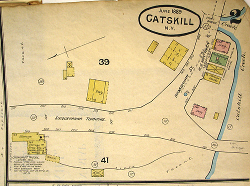
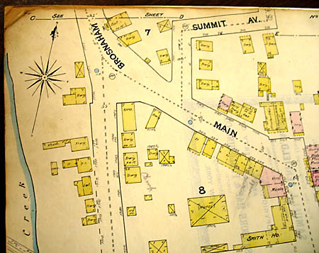

The Panoramic Map of Catskill drawn by L. R. Burleigh in 1889 shows the West Shore Bridge. A small section of the map, left, shows the railroad bridge trestle on the east side of Catskill Creek – in the middle of the map. This trestle sits on or close to the spot where Andrew Brosnaham’s hotel was probably located. There was a livery and stable associated with the hotel and a barn was one of the buildings noted on one piece of property when the land was eventually sold. This would have been where the horses or other livestock were kept when lodgers or travellers stayed at the hotel. If the barn or stables was adjacent to the hotel, most likely it was torn down also when the trestle was built. Brosnaham Street goes under the trestle bridge and continues on past Allen St. and over the Vosenkill bridge to where it runs into the Susquehanna Turnpike at the left of the picture. Andrew owned land bordering on the Vossenkill but the exact location is not known. To the left of Allen Street, one can see the little creek, the Vosenkill, meandering down to join Catskill Creek, the larger creek running left to right at the bottom of the map.4


The 1867 F.W. Beers Atlas of Catskill showing the probable location of Andrew Brosnaham's hotel.


A small section of the 1867 F.W. Beers Atlas of Catskill shows, next to the Vossenkill (creek) at the top center of the picture, the A.J.G. Hotel with a Livery Stable across the street. This stretch of street was called Brosnaham Street at one time. There are several buildings with the names Foot and A.J.G(rant), including the stable (livery). Alexander J. Grant and Gordon M. Foot, presumably related to J. B. Foot and A. Foot, were the two gentlemen who bought the property from John and Isabella Brosnaham in 1856 after the death of John's brother George in 1855.

The map has a list of business people listed at the bottom. One section lists all the hotel proprietors. In the middle is listed Geo. W. Loud who had a hotel and livery on Brushingham (Brosnaham) Street. The A.J.G. Hotel was actually owned by Alexander J. Grant who rented the building to George Loud.

Because Grant and Foot were the two men who bought the Brosnaham property in 1856, and because it is located where the railroad bridge would have gone through, it is likely that this was the location of Andrew Brosnaham’s hotel and property.


This house sits on what was once Brosnaham Street. It is thought that Andrew Brosnaham’s hotel was just to the right of this house, close to the bridge in this picture.

Andrew Brosnaham died 18 August 1833 when he was 75 years old. His older son George was still living at home. In 1846, a year before their mother, Margaret, died, George and his younger brother, John, who was living in Florida, completed a land transaction whereby all of their father’s land, which included some property in Herkimer County, was sold by George to John for $1 via a quitclaim deed. George then agreed to pay one cent per year in rent, if demanded by his brother, and in return he would continue to live on the property; he could lease the buildings from year to year, he agreed to keep the premises and the buildings in good repair and pay all taxes.5

Margaret died 4 August 1847, age 89, and George died 2 October 1855, never having married. After his death, John Brosnaham and his wife Isabella sold the land to Alexander J. Grant and Gordon M. Foote on May 16, 1856 for $10,000.6


  1. Records of Andrew's land purchases can be found at the County Clerk's Office in Catskill, Greene County, New York. Greene County was formed from Albany County in 1800, so many of Andrew's land purchases were made in Catskill, Albany County. The grantor-grantee records in the offices there are my source of information. The records give the names of the grantors and grantees, the date, the book and page where the info can be found. Descriptions of the land or lot sometimes give more precise information - "...part of a lot of land called lot #27 containing 695 acres situate and lying in the said Town of Catskill..." - while the actual description might be "...beginning at a stake and heap of stones..." or "...running down said creek at the low water mark..." or "...beginning at a pitch pine on the bank of Catskill Creek..." Andrew bought quite a bit of land in Catskill, beginning in 1790 and ending about 1832, the year before he died. In 1846 Andrew's son George sold his share of the land in a quitclaim deed to his brother John and his wife, Isabella Sierra, for $1.00. George died in 1855, and after his death John and Isabella sold the land
  2. Gallt, F.A. Dear Old Greene County: Embracing Facts and Figures, Portraits and Sketches, of Leading Men Who Will Live in her History…. Catskill, New York, 1915. Transcribed by Arlene Goodwin. Quote is from Section Five. Accessed at the website: Tracing Your Roots in Greene County. Greene County website at www.rootsweb.ancestry.com.
  3. This hand drawn map by F. Salisbury can be found at the Vedder Research Library, Coxsackie, New York.
  4. Greene County, New York, Deed Book L, pp.163-165. Deed recorded 21 Aug 1827 in Catskill. This parcel of land, purchased for $1,100 from Joseph and Mary Allen of Catskill, contained 11 acres.
  5. Greene County, New York, Deed Book 37, pp.164-166. Deed recorded 22 Aug 1846 in Catskill.
  6. Greene County, New York, Deed Book 53, pp.84-86. Deed recorded 11 June 1856 in Catskill.

Many thanks go to Sylvia Hasenkopf, a Greene County researcher, who went through all the recorded deeds which I had copied in Catskill, who found maps and other sources which helped to pinpoint the location of the Brosnaham Hotel. She went by car and on foot to scout out the locations marked on maps, and it was she who came to the conclusion that the hotel must have stood where the West Shore railroad bridge abutment stands today.

  • Photographs of the 1889 Sanborn Map taken by Anne Field, May 2007, at the Vedder Research Library in Coxsackie, New York.
  • The Panoramic Map of Catskill by L.R. Burleigh can be viewed in its entirety at the Library of Congress website www.memory.loc.gov by searching under Burleigh and Catskill; reprints can also be purchased online.
  • The 1867 F.W. Beers Atlas of Greene County, New York, which includes the map of Catskill, is available at the Family History Library in Salt Lake City, Utah, and in the offices of the County Clerk in Catskill, New York.
  • The photograph of the white house next to the bridge was taken by Greene County researcher Sylvia Hasenkopf.

Anne Healy's Genealogy
Created October 2002
This page created 7 Dec 2008
updated 31 July 2021

Photographs and web page content, Copyright © 2002- , Anne Field, all rights reserved. Please feel free to link to my web page. Please do not copy and paste my images onto other webpages without permission. For permission to use any pictures or content on my web pages, please email me at


[home|brosnahan|andrew brosnaham]